New Imaging Blog Space

In tandem with this Blog site we have another Blog site which is devoted to Landscape Research through imaging particularly 3D imaging.

You can visit the LRC Imaging Blog by following the link below where you can see examples of 3D imaging projects including experimental work using drones, the recording of excavations and of individual objects.

http://www.landscaperesearchcentre.org/wp/

To see the full range of 3D imaging experiments in progress please visit our Sketchfab space

we hope you enjoy what you see

Dominic Powlesland

Director


Posted in Archaeology | Leave a comment

The Archaeologist’s Shoes

Shoes_DSC7674_reduced


The Landscape Research Centre has been actively involved in rescue archaeology at Cook’s Quarry, West Heslerton, North Yorkshire in the Vale of Pickering since a visit by the director in 1977. The original excavations at Cook’s Quarry were published in the Journal of the Royal Archaeological Institute in 1986 (Powlesland, D.J., Haughton, C.A. and Hanson, J.H. 1986 ‘Excavations at Heslerton, North Yorkshire 1978-82’, Archaeol. J. 143, 53-173). Since then with the exception of a gap in excavation during the late 1980s and early 1990s, when parts of the quarry were extended without any archaeological observation, excavations have continued to examine and record areas prior to sand extraction on an almost biannual basis.

The cumulative results of these excavations have confirmed the importance of the Cook’s Quarry site with reference to the Prehistory of the North of England including the excavation of possible major Late Mesolithic or Neolithic but as yet undated post settings (?5000-4000 BC), Beaker period (2500-1800 BC) domestic settlement areas, including the examination of what appears to have been a Beaker kiln, Late Bronze age settlement and cemetery (1100-800 BC).  A relict stream channel which formerly ran across the site seems to have served as the focus for activity, perhaps followed as a route through the landscape from as early as 10,000 BC, with concentrations of activity such as flint working on the banks of the stream throughout the prehistoric period.

Three seasons of fieldwork remain, with stripping part of the area formerly used as the excavation camp-site recently completed. During the 1970s, 80s and 90s the excavation camp-site housed teams of up to 120 volunteers resident for many weeks. The excavation had a tremendous impact on the village in what was then a fairly isolated place in Britain. Each year a deep rubbish pit was cut into which the chemical toilets used in those days were emptied, at the end of the season there was always material left by departing team members, most of this was disposed off-site in a skip but some made its way into the cess pit.

You can imagine our excitement this week when, during the cleaning of the new area we discovered a remarkably well preserved, but somewhat worn pair of red Dr Martens, a long time preferred shoe for the itinerant archaeologist, shoes that were both comfortable and more importantly made little impression on the fragile sandy deposits on site. The section through the pit can be seen in the image above. Alternatively look at the 3Di model published on our Sketchfab site to see the Shoes and section in 3D. We hope that Dr Martens will be able to give us a precise date for these magnificent artifacts.

https://skfb.ly/DRwM

More to follow…..

UPDATE

The section with the shoes has been re-photographed, although still in difficult bright conditions, and remodelled at higher resolution. Follow the link below

https://skfb.ly/DS7E


Posted in 3Di, 3Di 3D Imaging, Archaeological Excavation, Archaeology, vale of pickering | Leave a comment

Digital Atlas Temporary Address

The LRC Digital Atlas has been functioning almost flawlessly for a number of years, unfortunately recent changes (upgrades ) of the windows server, where it is hosted, seem to have caused data serving problems which have stopped it from functioning all-together.

Whilst the problem at the host end is being resolved a new version has been installed on the LRC archive server, which although very slow does work as intended with the exception of one or two image files.

very slow should perhaps be amended to exceptionally slow, a consequence of the poor connection between the LRC server and the internet resulting from our relatively remote location. The check box which loads the geophysical survey results (hundreds of megabytes of data) is particularly slow, when clicked it may take 10 minutes before the time bar shows that the data has loaded.

this can be reached by following the link below

http://dpowlesland.ddns.net/ATLAS/

Posted in air photography, Archaeology, crop mark, Digital Atlas, Digital Heritage, Geophysics, Landscape, vale of pickering | Tagged | Leave a comment

Archaeology and contemporary art: A Hidden Landscape, by Paul Musgrove

New Exhibition at Ryedale Folk Museum

 A Hidden Landscape, by Paul Musgrove (7th June – 20th July 2014)

Paul Musgrove with glass sculptures in the foreground and woodblock prints behind

Paul Musgrove with glass sculptures in the foreground and woodblock prints behind


The Ryedale Folk Museum, situated just outside Kirkbymoorside, on the edge of the North York Moors is a little gem of a museum which combines archaeological, architectural and craft collections with one of the most comprehensive collections of treen and other post-medieval domestic artifacts to be found in any rural museum in Britain. It also has a small but stunning single room art gallery, established in 2011 for a small temporary exhibition of works by Barbara Hepworth, Henry Moore and Terry Frost.

The gallery provides a splendid setting for the latest exhibition by printmaker and glassworker Paul Musgrove. More than 30 works are in the exhibition which combines a number of unique glass ‘standing stones’ and a variety of Japanese wood-block prints and etchings many of which have been inspired by the results of air-photographic and geophysical surveys and excavations undertaken over more than 3 decades by the Landscape Research Centre in and around the Vale of Pickering. During the first few years of the rescue excavations begun at Cook’s Quarry, West Heslerton in 1978 Paul was an active member of the excavation team and site photographer.

The gallery is little publicised, but must be one of the best exhibition spaces to be found in the region. In addition to examples of work derived from the major archaeological surveys a lot of new work influenced by the buried archaeological landscape of the Vale is joined by others influenced by visits to Orkney and other part of Scotland, where Paul is based.

Having visited a number of Paul Musgrove’s exhibitions over the last few years this is exceptional both in terms of the work presented and the gallery space. The work on display is exciting and affordable whether you are interested in his Archaeoprint series or by the fabulous glass table-top sculptures. A very fine example of the influence of archaeology on contemporary art.

???????????????????????????????

Posted in Archaeology, art, crop mark, Landscape, vale of pickering | Tagged , , | 1 Comment

3Di or 3D Imaging from Free Range Photography

Hov3D_Sony_RX100

3Di Model of the eroded Anglo-Saxon Angel Frieze now protected within the church in Hovingham, North Yorkshire, (this version clipped on the right hand side). Generated using Agisoft Photoscan Pro from 20Mp images gathered using a Sony RX100 pocket camera

Over the past 4 years the LRC has undertaken a series of experiments designed to evaluate the potential for digital photogrammetery to enhance the  archaeological record from archaeological excavations. More recently a spell as Field Archaeologist in Residence in the McDonald Institute of Archaeological Research in the University of Cambridge enabled me to devote some time to a more in depth assessment of the potential of the method and to work with a number of others to showcase what I consider to be one of the most significant breakthroughs in computer applications for the field archaeologist.

The combination of a relatively high quality and high resolution digital camera with good lenses, a powerful desktop computer equipped with a gaming graphics card and software operating freely using cloud computing facilities or commercial software running on the local computer can generate very high resolution 3D Images or 3Di Models of excavated trenches and features with millimetre accuracy from a small number of carefully collected digital photographs. The 3D models resulting from this process enhance the record by revealing detail that cannot conventionally be recorded on paper, particularly relating to soil textures which can be enhanced by the use of carefully placed virtual lighting. In addition they can be manipulated on a web-page  or published within 3D PDF files in a format that supports measurement and model sharing in a way that is not otherwise possible. The product of the research in Cambridge will be more fully discussed in a Guide to 3D imaging for Archaeological Excavations due to be completed in June of this year.

In the meantime it has become very clear that the approach which employs sophisticated computing algorithms including Structure from Motion  offers tremendous potential in other fields in the Arts and Humanities beyond the relatively limited field of archaeological excavation recording. The potential to create highly accurate, shareable and measurable models for instance of Anglo-Saxon Carved Sculptural Stone or Inscriptions that can be shared between academics working in diverse locations around the world at the same time as making models that can be viewed online available to school-children or the retired has the potential to transform the  work of Historians, Linguists, Art Historians and others in the study and analysis of material much of which is inaccessible either because of its physical location in a building or simply because it is located in another country. Click on either of the two models pictured here to view the 3D models. These Models are large and thus may take a while to download and display if your connection is poor or computer is low powered. To be able to rotate the models correctly Google Chrome has proven to be the most consistent browser

Models generated of a recently discovered Runic Inscription were circulated amongst the community of runologists for comment over a few weeks rather than wait for years until each had had the opportunity to see the inscription in situ.

The experiments have been looking both at the process as well as the results this has included the comparison of both photographic equipment and software. To get an idea of the quality of the results you can view the experimental results on our Sketchfab site, (https://sketchfab.com/d.powlesland) which employs the Sketchfab viewer to display 3D models on a web-page or download some of the samples in PDF files, from the Cambridge University Digital Repository (D-Space) which provides a permanent digital archiving facility within the university. If you open a PDF from the D-Space it may open as a blank PDF in your browser with just the model title in the lower right corner; if this is the case download and open the file from your downloads directory using the Adobe PDF Viewer.

3D Model created using Agisoft Photoscan Pro from Digital Images gathered using a 16Mp Olympus OM-D EM-5

3D Model created using Agisoft Photoscan Pro from Digital Images gathered using a 16Mp Olympus OM-D EM-5

The 3D Models archived at Cambridge have all been generated using Agisoft Photoscan Professional (http://www.agisoft.ru/products/photoscan/professional) whilst those on the Sketchfab  include others generated using free online processing services available through the ARC 3D WebService (http://homes.esat.kuleuven.be/~visit3d/webservice/v2/) or Autodesk 123D Catch (http://www.123dapp.com/catch)

Posted in 3Di 3D Imaging, Archaeology, art, Digital Heritage, Photogrammetery | Tagged , , | Leave a comment

3D imaging experiments at Boltby Scar

Boltby Scar Section through Bronze Age Round Barrow

Boltby Scar Section through Bronze Age Round Barrow


The Landscape Research Centre has been at the forefront of research into digital recording techniques for the field archaeologist since it adopted the use of handheld computers for recording in the field in the mid 1980s.

A series of small excavations on the severely damaged remains of a Late Bronze Age-Early Iron Age Hillfort at Boltby Scar on the North York Moors have been the setting for a series of 3D imaging experiments employing, with the assistance of Leica UK 3D laser scanners and 3D Imaging from photography. The link below gives an idea of the level of detail returned in a photographic 3D model of a section through a robbed Bronze Age barrow, note the turf deposits showing towards the two ends of the section where the mound had suffered least disturbance. The extraordinary levels of detail documented using this method has underpinned a significant re-interpretation of the evidence documented during the excavation which would not have been possible from the examination of the 2D static images alone.

Click here to see the Boltby Scar Barrow Section.

Posted in Archaeology, Digital Heritage | Leave a comment

Dry hot spell following horrendous long wet winter exposes hidden archaeology and other things lurking in the fields.

Aliens3rCropped

Climate change, increasingly industrialised agriculture and changes in the crops being grown are influencing our knowledge of the past. The relatively extreme weather patterns that we are experiencing in Britain influence the way that arable crops grow revealing archaeological features buried and forgotten often for thousands of years. These crop marks, a function of contrasts between the undisturbed subsoil and cut features such as ditches and pits or structural foundations result from differential growth patterns which have influenced the development of the root system and thus the speed at which crops ripen or suffer from stress in dry spells like we are having at present.

Air photography  over the last century has been the biggest single contributor to our knowledge of the scale of past settlement in Britain. It has become blatantly obvious during the last twenty years that new and previously unknown features have been appearing even in very extensively studied landscapes and that their appearance owes much to the increase depth of ploughing that has accompanied the introduction of ever bigger farm machinery. Deeper ploughing cuts away and disturbs buried archaeological deposits such as the floor layers of prehistoric houses, mixing the material in the plough soil and leaving only truncated features beneath. Pits, ditches, wall footings or post-holes that cut deeper than the depth of the plough will ultimately be all that survives this modern hyper mechanised agricultural revolution and will, if we are not careful, be all that is left to help us understand human interaction with the British landscape over the last 12,000 years. A casual look at the Yorkshire Wolds in winter, when large areas of ploughed fields can be seen, indicates the levels of plough damage that have changed the thin plough-soil to a material mostly made of rock.  The Wolds are becoming whiter every year as more chalk is broken up and added to the plough-soil, the chalk of the Wolds has not been so exposed since the last glaciers receeded.

The crops are late and the weeds confused but as the weather has settled down, leaving many in a state of disbelief, the crops have started to turn, producing crop marks that were last seen emerging at the beginning of May last year, before the deluge began. Field archaeologists are as tied to the weather as farmers, even more so if they are also engaged in aerial archaeology, if this present dry hot spell continues we would expect to see crop marks all over Britain and new discoveries made every flight; filling in gaps in the human landscape that could only be otherwise approached with a vast investment in ground based geophysical surveys and on the ground investigation.  The combination of factors of climate, crop, soils, local and short term weather creates conditions that are effectively unique every day, conditions that may expose vast areas of hidden archaeology even if most often we are unable to securely date and precisely interpret what we see.

Seen from the air the landscape wears the effects of human intervention:

Allotments_Reduced

The pattern derived from the resurgence in the use of garden allotments

CM_nearDriffieldP7140463

Enclosures and track-ways from a probable Iron Age or Roman settlement cut through by a now abandoned railway line and trapped between a modern housing estate and a golf course. 

AP_IAenclosure7140482

What appears to be an Iron Age farmstead with a single roundhouse in a rectangular enclosure in an environment with poor drainage as demonstrated by the network of field-drains which cut through both the enclosure and what appears to be a track-way and other less clear features in the left hand part of the frame.

??????????????????????

Some people, I understand, believe that crop circles are the product of Aliens, if this is the case one wonders what sort of ambitions this particular crew had when they created these marks in a field near Poppleton just outside York. I suppose this provides some context for my four year old who refers to Crop-marks as Crock Marks..or maybe he is saying something else.

Posted in air photography, Archaeology, crop mark, crop-circle | 2 Comments

Bathroom Lost and Found at Hovingham Hall

Roman Bath House re-discovered at Hovingham, North Yorkshire more than 250 years after it was first uncovered.

All too often archaeologists talk about ‘new’ discoveries, a curious concept in world where the focus of study is about the past.   During February and March 2008 the Landscape Research Centre undertook a geomagnetic geophysical survey at Hovingham as part of a project designed to gain some understanding of the scale of the archaeological resource in the Vale of Pickering that might be at risk from the extraction of aggregates. This work was part of a very large project concentrated in the eastern part of the Vale. In order to establish the degree to which the extraordinary results emerging on the sands and gravels between Rillington and Potter Brompton to the east of Malton reflected a more widespread picture small sample areas were examined elsewhere in the Vale for comparison. We were fortunate enough to be granted permission by the Hovingham estate to undertake a geophysical survey in the Park at Hovingham Hall where antiquarian discoveries pointed towards the presence of Roman structures. The survey was undertaken both to test the appropriateness of using gradiometery on the sands and gravels which fill the river valleys entering the Vale of Pickering at the western end but also to try and discover the location and context of a Roman bath house unearthed here in the early 18th Century when an ornamental canal was constructed during a massive landscaping campaign initiated by the 5th Thomas Worsley who inherited the estate in 1715..

The bath house is discussed in a letter sent on June 7th 1749 from Francis Drake (not the one with a boat, but the author of Eboracum with the catchy subtitle of ‘The History and Antiquities of the City of York, from its Original to the Present Time; together with the History of the Cathedral Church and the Lives of the Archbishops’) to William Stukeley, perhaps the pre-eminent early English Antiquarian. The letter along with others was published in a volume of the Surtees Society following a meeting of the society on December 4th 1877, with the great Yorkshire archaeologist Canon Greenwell in the chair in which it was ordered

“that a Selection from the Gale and Stukeley Correspondence should be edited for the Society by the Rev. W. C. LuKis.” 

This was duly published in 1882 as ‘The family memoirs of the Rev. William Stukeley, M.D., and the antiquarian and other correspondence of William Stukeley, Roger & Samuel Gale, etc (Volume 3)’  this is available for download as an e-book or can be read on the internet.

Although the letter does not indicate the date of discovery of the Hovingham Bath House or for that matter much detail as to the nature of the discoveries it is however nevertheless very entertaining as a reflection of archaeological response times. Part of the letter is included below..

“ The interruption or our correspondence has been occasioned by
 some mistake ; it is near a year ago since I wrote to you to
 Stamford, and sent by the York carrier, at the same time, a 
 duzzon of prints from a plate of a Roman bagnio and pavement
 found lately at Hovingliam, near us, and published at the
 expence of Lord Burlington. I believe this was some time before 
your remove to London, for I saw an account of that in the 
news-papers afterwards. I am affraid both my letter and the 
prints miscarried; for I have never heard one word from you 
since about them.”  

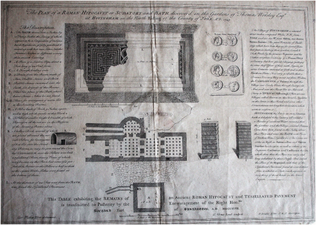
The letter then goes on to point out that a plate made by Virtue and funded by Lord Burlington was in London if he wished to have any prints made from it. The Society of Antiquaries of London has a copy of the etching as do the Worsley family at Hovingham Hall, the etching is reproduced below with permission of Sir William Worsley. It shows parts of a Roman Bath House, some examples of the pilae (used to support heated floors in Roman bath houses), one of a number of tubuli  (vertical flue pipes designed to heat the walls), a plan of a damaged room with a partial mosaic situated some 221 feet away from the Bath house, and references a few coins and other finds recovered during the uncovering of the structure. A small (less than 25cm square) fragment of the illustrated mosaic survives as a family heirloom.

New Picture (1)

The Hovingham Bath-House as illustrated in 1747

Although the location of the Bath House excavation is indicated on a map of the Park drawn in 1760 the precise location has remained unclear since. According to the late Sir Marcus Worsley the Canal itself was not a particularly successful feature of the park and by 1824 it had been re-modelled by opening out the western end into a broad but shallow lake, perhaps in the hope of increasing the water catchment to support the flow through the canal. In the end the limitations of the water supply meant that both the lake and the canal silted up and it became un-economic to maintain them as landscape features. Parts of the canal can still be detected on the ground through the survival of shallow banks on either side, but even the 1842 plan suggests that the site of the Bath House was obliterated by the lake extension and that the building with the mosaic was probably bisected by the stream which flows though the park and has most likely been lost entirely either as a result of erosion from the stream or enthusiastic antiquarian activity in the18th Century.

The original geomagnetic survey exposed many features relating to the ornamental canal and lake but failed to reveal the location of the Bath House, even using measurements from the early map to isolate the most likely location and undertaking a higher resolution survey than would normally be possible we could not see any convincing evidence of the structure.  Elsewhere in the survey there were indications of possible walls, suggesting that the approach was not entirely inappropriate and thus that the Bath house remains had either been completely destroyed during the various enhancements to the park or that it was obscured as a consequence of the silting up of the canal and or lake.

In 2013 it was decided that further research using alternative geophysical survey methods might give a better return than the geomagnetic survey. The Landscape Research Centre (LRC) has recently established a co-operative research agreement with the Initiative College for Archaeological Prospection (IC-ArchPro) at the University of Vienna, perhaps Europe’s leading archaeological remote sensing centre. The IC-ArchPro is at the forefront of developments in high speed high density geophysical survey and has a range of equipment not normally available to the LRC including a highly sophisticated multi-channel Ground Penetrating Radar (GPR) instrument. An appeal to the IC-ArchPro for help at Hovingham was given an immediate and positive response and a team from Vienna brought a range of instruments, including the high density radar instrument and undertook a large area survey at Hovingham between March 30th and April 4th 2013.

GPR instruments are usually notoriously slow to use for archaeological survey as they tend to be very heavy and have to be dragged by hand across the survey area; the University of Vienna system is dragged by a quad-bike and also in contrast with conventional methods generates data that can be viewed within an hour of the survey completion, rather than needing several days of post-processing. The GPR works by transmitting and receiving radar pulses that are recorded as subsurface slices reflecting material density at different depths determined by the time taken for the radar signal to be returned to the instrument receivers.

In the case of Hovingham the GPR was able to confirm that the walls of the bath-house buried at a depth of over a metre still survived beneath the present ground surface. The mystery of the lost bathroom at Hovingham hall is now resolved, other walls identified nearby may indicate the presence of other structures in the immediate vicinity, but a shortage of time precluded further survey to see if the location of the building with the mosaic fragments could be found. It is now hoped that the team from Vienna will return later in the year to extend the survey area and try and identify the context for what in terms of plan looks like a rather unusual and large bath-house for its rural setting.

lrc_Mag_hov_bath_ed


Geomagnetic survey at Hovingham intended to find the location of the missing Bath-House

IC_Archpro_GPR_hov_bath_ed

Ground Penetrating Radar Survey (overlaid upon the geomagnetic survey) which confirmed the location of the Bath-House excavated in the eighteenth century

Posted in Archaeology, Geophysics, Landscape, vale of pickering | Tagged , , , , , | Leave a comment

Vale of Pickering: Statement of Significance

Archaeological research in the Vale of Pickering over the last 35 years has identified an entirely unanticipated level of past activity, particularly around the margins of the valley which formerly held the largest inland body of water in Britain. Lake Pickering, which has featured in school geography lessons for many generations, mostly drained away about 12,000 years ago leaving a broad wetland with a network of interconnected lakes in the centre of the Vale and extensive light sandy soils on the margins of the valley, particularly in the eastern half. Air-photography, geophysical survey, excavations and other fieldwork undertaken by the Landscape Research Centre (LRC) and the Vale of Pickering Research Trust (VPRT) have completely transformed our understanding of the archaeology of the Vale from the Late Palaeolithic to Medieval periods. Although this research has been the subject of countless public lectures in Britain and abroad as well as numerous publications and exhibitions in Malton and in Scarborough its significance within the region, in Britain and Europe has not been widely appreciated.

The focus of much of the research in the Vale has, in the case of the VPRT been on the landscape around the former Lake Flixton and the internationally important site of Star Carr, and in the case of the LRC centred on the huge excavations undertaken at West Heslerton and landscape scale surveys covering many square kilometres to the east and west. The results of both research programmes indicate that what we have seen up to now is merely a sample of much more extensive archaeological resources which show much higher past populations and, although apparently ‘unique’, are a reflection of the scale and intensity of activity we should expect in similar valley landscapes elsewhere in lowland Britain. The element of ‘uniqueness’ reflects, more than anything else, the level, intensity and focus of recent discovery and research but nevertheless it also highlights the importance and potential of the archaeology of the Vale.  In the words of the former Chief Archaeologist for England David Miles ‘the buried landscape of Heslerton is every bit as important as Stonehenge‘.

In 2011-12 English Heritage commissioned the production of the ‘Vale of Pickering: Statement of Significance’, a document designed to highlight the nature and importance of the heritage of the Vale. The preparation of a Statement of Significance is the first stage in developing an overall strategy for the Vale of Pickering, as part of the Vale of Pickering Historic Environment Management Framework Project, initiated by English Heritage (Yorkshire and Humber Region). The Statement of Significance document has been prepared by Dr Louise Cooke in collaboration with a wide range of stakeholders, both organisations and individuals, representing a range of different backgrounds and interests including cultural and natural heritage, and planning.

The document is designed to be used by many from heritage agencies and planners to school teachers and academics to underpin planning policies that help sustain heritage resources or the development of long term research strategies to enhance a more detailed understanding of the fragile evidence of the past which is increasingly under threat from industrial farming and other developments.

The detailed statement of significance document can be downloaded from the North Yorkshire County Council Website at:

http://www.northyorks.gov.uk/CHttpHandler.ashx?id=22213&p=0

The document is summarised in ‘The Vale of Pickering an Extraordinary Place: Statement of Significance’ which can be downloaded by clicking on the link here.

The Vale of Pickering an Extraordinary Place Statement of Significance

Posted in air photography, Archaeological Excavation, Archaeology, Geophysics, Landscape, vale of pickering | 2 Comments

Mind The Gap an international seminar on Emptiness, Visibility, Ambiguity and Absence in Archaeology

 
Mind_The_Gap_Logo_by_rrward

University of Siena – Department of Historical Studies and Cultural Heritage

Landscape Archaeology and Remote Sensing LAB

Absence, invisibility and emptiness

in the interpretation of archaeological and landscape evidence

AN INTERNATIONAL SEMINAR AND DEBATE

22-24 APRIL 2013, CERTOSA DI PONTIGNANO, SIENA, ITALY


2½ days of discussion plus optional ½ day visit to Siena

Presentations and discussion in international English, with subsequent internet publication and continuing web-based discussion

Data collection and archaeological interpretation are complicated by apparent gaps in the evidence, whether in excavation, geophysical prospection, remote sensing, field survey, environmental analysis or artefact studies.

How can we tell whether such ‘gaps’ represents an absence of evidence, a failure to see evidence that is potentially available, the removal of evidence that was once present or a real gap in the activity or sequence that we are studying?

To what extent can we cope with such uncertainties when moving from data assembly to realistic archaeological interpretation?

Ambiguities of this kind are inherent in archaeology as a study based on the observation of material evidence. The seminar will explore these challenges through discussion between a dozen argumentative speakers and thirty or so interested students, teachers, researchers and practitioners, both at the initial seminar and in web-based discussion afterwards.

Subjects covered will include aspects of excavation, field survey, geophysical prospection, aerial survey, landscape interpretation, environmental reconstruction and the use of numismatic evidence.

If the seminar and its subsequent web-based discussion are successful consideration will be given to the promotion of similar events in future years.

INTRODUCTORY PRESENTATIONS


STEFANO CAMPANA (University of Siena)

Emptiness in Archaeology and the code of silence

JOHN CASEY (Independent archaeologist and numismatist)

When the money is missing: case studies in the constructive use of numismatic evidence

DAVE COWLEY (RCAHMS – Royal Commission on the Ancient and Historical Monuments of Scotland)

How big a gap? Some thoughts on scale, emptiness and bias

MARK EDMONDS (University of York)

Necessary spaces: real and imagined emptiness in Later Prehistory

ROSE FERRABY (University of Exeter)

Drawing out the gaps: Using images to explore absence in the landscape

DARJA GROSMAN (University of Ljubljana)

Hidden in stone, mud and water

ROG PALMER (freelance air photo interpreter)

Why are there holes in aerial data? And do we need a typology of gaps?

DOMINIC POWLESLAND (Landscape Research Centre)

Mind the Gap: emptiness and empty-heads in the study of past landscapes

JAMES RACKHAM (Independent environmental archaeologist & University of Nottingham)

So few pieces of the jigsaw! Just how good can our landscape and palaeoeconomic reconstructions be?

FRANK VERMUELEN (University of Ghent)

Surveying an Adriatic valley: from meaningless dots to meaningful gaps

EZRA ZUBROW (University of Buffalo)

Measuring Emptiness


PRELIMINARY EXPRESSIONS OF INTEREST ARE INVITED FROM INDIVIDUALS, IN WHATEVER FIELD OF ARCHAEOLOGICAL RESEARCH, WHO FEEL THAT THEY COULD CONTRIBUTE TO AND/OR BENEFIT FROM THIS KIND OF DISCUSSION.

Presence throughout the full 2½ days of the discussions is obligatory, at an all-in residential cost of about €150 per person (non-refundable deposit of €50, plus remainder on arrival).

Register your interest, please, by emailing campana@lapetlab.it as soon as possible, including a very brief statement of your past experience and reason for wanting to take part.

Further details and an application form will be available via the ArchaeoLandscapes website (www.archaeolandscapes.eu) in mid-February.  Firm applications to be submitted by 1 March. Full inscription and payment of deposit by selected participants will be confirmed in mid-March.

Limited financial help, through the ArchaeoLandscapes Europe Project, will be available for those who cannot meet the full cost of attendance and travel from their own or other sources.

The seminar forms part of the ArchaeoLandscapes Europe Project within the Culture Programme of the European Union, managed in this case by the Roman-Germanic Commission of the German Archaeological Institute in Frankfurt.

The event is being organized by Stefano Campana of the Laboratory of Landscape Archaeology and Remote Sensing (LAP&T), University of Siena, in partnership with Chris Musson and Prof Dominic Powlesland of the Landscape Research Centre in the UK.

Posted in air photography, Archaeological Excavation, Archaeology, Geophysics | Tagged , , , , , , | Leave a comment